قائمة مقاطعات نبراسكا
القائمة التالية هي قائمة مقاطعات ولاية نبراسكا, ويبلغ عددها 93 مقاطعة.
| مقاطعات نبراكسا | |
|---|---|
| نوع التقسيم | دولة اتحادية |
| الدولة | نبراسكا |
| العدد | 93 |
| السكان | 444 (مقاطعة أرثور (نبراسكا)) – 463,585 (مقاطعة دوغلاس (نبراسكا)) |
| المناطق | 241 ميل مربع (620 كـم2) (مقاطعة ساربي (نبراسكا)) – 5,961 ميل مربع (15,440 كـم2) (مقاطعة تشيري (نبراسكا)) |
| الحكومة | حكم محلي |
المقاطعات
| مقاطعة |
FIPS [1] |
مقر المقاطعة [2] |
تاريخ التأسيس [2] |
المنشأ |
أصل التسمية | الرمز الدلالي للوحة التسجيل [3] |
تعداد السكان [2] |
المساحة [2] |
الخريطة |
|---|---|---|---|---|---|---|---|---|---|
| مقاطعة آدمز | 001 | Hastings | 1867 | Unorganized territory | جون آدامز, Founding Father and the second رئيس الولايات المتحدة | 14 | 31٬151 | 563 sq mi (1٬458 كم2) | 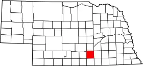 |
| مقاطعة أنتيلوبي | 003 | Neligh | 1871 | Unorganized territory | الظبي الأمريكي, often called ظبي | 26 | 7٬452 | 857 sq mi (2٬220 كم2) | 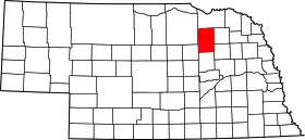 |
| مقاطعة أرثور | 005 | Arthur | 1887 | Unorganized territory | تشستر آرثر, twenty-first رئيس الولايات المتحدة | 91 | 444 | 715 sq mi (1٬852 كم2) | 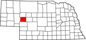 |
| مقاطعة بانر | 007 | Harrisburg | 1888 | Formed from Cheyenne County | Named for the hope of the early settlers to make the county the "banner county" of the state | 85 | 819 | 746 sq mi (1٬932 كم2) | 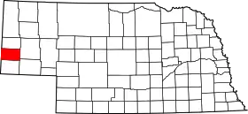 |
| مقاطعة بلاين | 009 | Brewster | 1885 | Unorganized territory | جيمس جي بلين (1843-1923), مجلس النواب الأمريكي, الناطق باسم مجلس النواب الأمريكي, مجلس الشيوخ الأمريكي from مين, وزير الخارجية الأمريكي, and الحزب الجمهوري (الولايات المتحدة) candidate in the انتخابات الرئاسة الأمريكية 1884 | 86 | 583 | 711 sq mi (1٬841 كم2) | 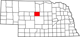 |
| مقاطعة بوني | 011 | Albion | 1871 | Unorganized territory | دانيال بون, American pioneer and trapper | 23 | 6٬259 | 687 sq mi (1٬779 كم2) | 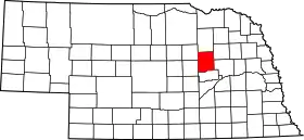 |
| مقاطعة بوكس بوتي | 013 | Alliance | 1887 | Formed from Dawes County | Named for a large box-shaped شاهد صخري located approximately six miles north of أليانس, the county seat. | 65 | 12٬158 | 1٬075 sq mi (2٬784 كم2) | 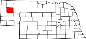 |
| مقاطعة بويد | 015 | Butte | 1891 | Holt County and unorganized territory (Indian Territory) | جيمس اي بويد, the eighth governor of Nebraska | 63 | 2٬438 | 540 sq mi (1٬399 كم2) | 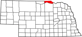 |
| مقاطعة براون | 017 | Ainsworth | 1883 | Unorganized territory | The Brown family of early settlers | 75 | 3٬525 | 1٬221 sq mi (3٬162 كم2) | 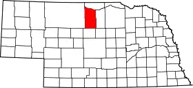 |
| مقاطعة بفلو | 019 | Kearney | 1855 | Unorganized territory | Named for the بيسون أمريكي which once roamed the present county | 9 | 42٬259 | 968 sq mi (2٬507 كم2) | 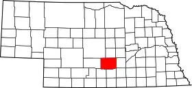 |
| مقاطعة بورت | 021 | Tekamah | 1854 | One of nine original counties | فرنسيس بيرت (سياسي), the first territorial governor of Nebraska who died after two days in office. | 31 | 7٬791 | 493 sq mi (1٬277 كم2) | 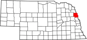 |
| مقاطعة بوتلر | 023 | David City | 1856 | Formed from Greene County | ويليام أورلاندو باتلر, U.S. Congressman from كنتاكي and الحرب المكسيكية الأمريكية hero | 25 | 8٬767 | 584 sq mi (1٬513 كم2) | 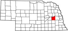 |
| مقاطعة كاس | 025 | Plattsmouth | 1854 | One of nine original counties | لويس كاس, the territorial administrator and U.S. Senator from ميشيغان | 20 | 24٬334 | 559 sq mi (1٬448 كم2) | 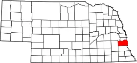 |
| مقاطعة سيدار | 027 | Hartington | 1857 | Formed from Dixon and Pierce Counties | Named for the eastern red cedars present in the county[4] | 13 | 9٬615 | 740 sq mi (1٬917 كم2) | 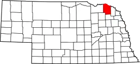 |
| مقاطعة كيس | 029 | Imperial | 1873 | Unorganized territory | شامبيون إس. شايس [الإنجليزية], a mayor of أوماها (نبراسكا) who served as نبراسكا's first attorney general | 72 | 4٬068 | 894 sq mi (2٬315 كم2) | 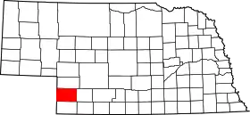 |
| مقاطعة تشيري | 031 | Valentine | 1883 | Unorganized territory | Samuel A. Cherry, army lieutenant killed in the الحروب الهندية الأمريكية | 66 | 6٬148 | 5٬961 sq mi (15٬439 كم2) | 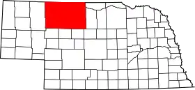 |
| مقاطعة تشيني | 033 | Sidney | 1867 | Unorganized territory | Named for the شايان (قبيلة) السكان الأصليون في الولايات المتحدة tribe | 39 | 9٬830 | 1٬196 sq mi (3٬098 كم2) | 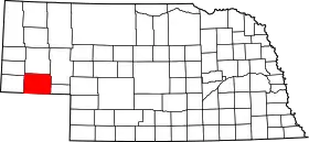 |
| مقاطعة كلاي | 035 | Clay Center | 1855 | Formed from unorganized territory | هنري كلاي, the Senator from كنتاكي, وزير الخارجية الأمريكي, and presidential candidate | 30 | 7٬039 | 573 sq mi (1٬484 كم2) | 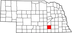 |
| مقاطعة كولفاكس | 037 | Schuyler | 1869 | Formed from Platte County | سكايلر كولفاكس, الناطق باسم مجلس النواب الأمريكي and نائب رئيس الولايات المتحدة | 43 | 10٬441 | 413 sq mi (1٬070 كم2) | 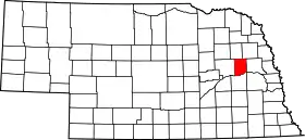 |
| مقاطعة كومينغ | 039 | West Point | 1855 | Formed from Burt County | Thomas B. Cuming, first Secretary of Nebraska Territory | 24 | 10٬203 | 572 sq mi (1٬481 كم2) | 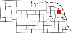 |
| مقاطعة كستر | 041 | Broken Bow | 1877 | Unorganized territory | جورج أرمسترونغ كاستر, general in the الحرب الأهلية الأمريكية and الحروب الهندية الأمريكية | 4 | 11٬793 | 2٬576 sq mi (6٬672 كم2) | 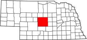 |
| مقاطعة داكوتا | 043 | Dakota City | 1855 | Formed from Burt County | Named for the لاكوتا (قبائل) branch of the سايوكس السكان الأصليون في الولايات المتحدة tribe | 70 | 20٬253 | 264 sq mi (684 كم2) | 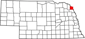 |
| مقاطعة داوز | 045 | Chadron | 1885 | Formed from Sioux County | جيمس دبليو. دوز, the sixth governor of Nebraska | 69 | 9٬060 | 1٬396 sq mi (3٬616 كم2) | 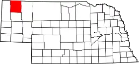 |
| مقاطعة داوسون | 047 | Lexington | 1860 | Unorganized territory | Jacob Dawson, the first postmaster in present-day لنكن (نبراسكا), the state capital | 18 | 24٬365 | 1٬013 sq mi (2٬624 كم2) | 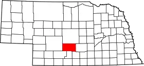 |
| مقاطعة ديويل | 049 | Chappell | 1888 | Formed from Cheyenne County | The Deuel family of early settlers | 78 | 2٬098 | 440 sq mi (1٬140 كم2) | 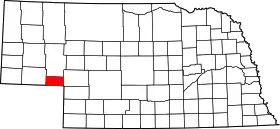 |
| مقاطعة ديكسون | 051 | Ponca | 1856 | Formed from Blackbird County, Izard County, and unorganized territory | The Dixon family of early settlers | 35 | 6٬339 | 476 sq mi (1٬233 كم2) | 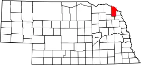 |
| مقاطعة دودج | 053 | Fremont | 1854 | One of nine original counties | Augustus Caesar Dodge, a United States senator from آيوا who was a supporter of the Kansas-Nebraska Act | 5 | 36٬160 | 534 sq mi (1٬383 كم2) | 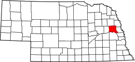 |
| مقاطعة دوغلاس | 055 | Omaha | 1854 | One of nine original counties | ستيفن أ. دوغلاس, the American statesman, U. S. senator, and presidential candidate | 1 | 463٬585 | 331 sq mi (857 كم2) | 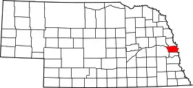 |
| مقاطعة دوندي | 057 | Benkelman | 1873 | Unorganized territory | Elmer Scipio Dundy, a U.S. Circuit Court judge from نبراسكا | 76 | 2٬292 | 920 sq mi (2٬383 كم2) | 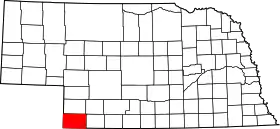 |
| مقاطعة فيلمور | 059 | Geneva | 1856 | Formed from Jackson County and unorganized territory | ميلارد فيلمور, the thirteenth رئيس الولايات المتحدة | 34 | 6٬634 | 576 sq mi (1٬492 كم2) | 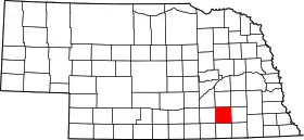 |
| مقاطعة فرانكلين | 061 | Franklin | 1867 | Formed from Kearney County | بنجامين فرانكلين, the Founding Father, printer, scientist, and diplomat | 50 | 3٬574 | 576 sq mi (1٬492 كم2) | 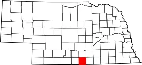 |
| مقاطعة فرونتير | 063 | Stockville | 1872 | Unorganized territory | Named for the fact that it was located in what was referred to at that time as part of the نبراسكا frontier | 60 | 3٬099 | 975 sq mi (2٬525 كم2) | 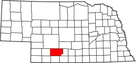 |
| مقاطعة فورناس | 065 | Beaver City | 1873 | Unorganized territory | روبرت ويلكينسون فورناس, the third governor of Nebraska | 38 | 5٬324 | 718 sq mi (1٬860 كم2) | 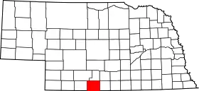 |
| مقاطعة غيج | 067 | Beatrice | 1855 | Unorganized territory | William D. Gage, a ميثودية minister who served as chaplain of the state legislature at the time the county was established | 3 | 22٬993 | 855 sq mi (2٬214 كم2) | 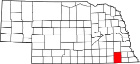 |
| مقاطعة غاردن | 069 | Oshkosh | 1910 | Formed from Deuel County | Named for the hopes of two real estate agents and citizens of the county seat, أوشكوش, that the county would be the "garden spot of the west" | 77 | 2٬292 | 1٬705 sq mi (4٬416 كم2) | 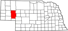 |
| مقاطعة غارفيلد | 071 | Burwell | 1884 | Formed from Wheeler County | جيمس جارفيلد, the twentieth رئيس الولايات المتحدة | 83 | 1٬902 | 570 sq mi (1٬476 كم2) | 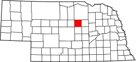 |
| مقاطعة غوسبر | 073 | Elwood | 1873 | Unorganized territory | John J. Gosper, the secretary of state for نبراسكا at the time of the county's formation | 73 | 2٬143 | 458 sq mi (1٬186 كم2) | 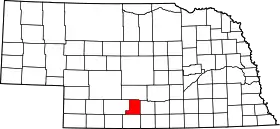 |
| مقاطعة غرانت | 075 | Hyannis | 1887 | Unorganized territory | يوليسيس جرانت, the eighteenth رئيس الولايات المتحدة and الحرب الأهلية الأمريكية general | 92 | 747 | 776 sq mi (2٬010 كم2) | 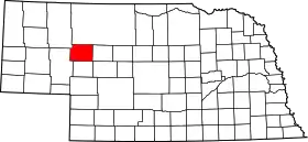 |
| مقاطعة غريلي | 077 | Greeley | 1871 | Unorganized territory | هوراس غريلي, the pioneering American journalist | 62 | 2٬714 | 570 sq mi (1٬476 كم2) | 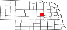 |
| مقاطعة هال | 079 | Grand Island | 1858 | Unorganized territory | أغسطس هال, the chief justice of the Territorial Supreme Court at the time the county was created | 8 | 53٬534 | 546 sq mi (1٬414 كم2) | 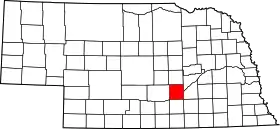 |
| مقاطعة هاميلتون | 081 | Aurora | 1867 | Unorganized territory | ألكسندر هاميلتون, the first وزير الخزانة الأمريكي | 28 | 9٬403 | 544 sq mi (1٬409 كم2) |  |
| مقاطعة هارلان | 083 | Alma | 1871 | Formed from Kearney County | Disputed; either جيمس هارلان, وزير داخلية الولايات المتحدة 1865-1866; or a revenue collector named Harlan who lived near ريبوبليكان سيتي (نبراسكا) | 51 | 3٬786 | 553 sq mi (1٬432 كم2) |  |
| مقاطعة هايس | 085 | Hayes Center | 1877 | Unorganized territory | رذرفورد هايز, the nineteenth رئيس الولايات المتحدة | 79 | 1٬068 | 713 sq mi (1٬847 كم2) |  |
| مقاطعة هيتشكوك | 087 | Trenton | 1873 | Unorganized territory | Phineas Warren Hitchcock, a مجلس الشيوخ الأمريكي from نبراسكا | 67 | 3٬111 | 710 sq mi (1٬839 كم2) |  |
| مقاطعة هولت | 089 | O'Neill | 1860 | Unorganized territory | جوزيف هولت, a U.S. Postmaster General and وزير حرب الولايات المتحدة under جيمس بيوكانان | 36 | 11٬551 | 2٬413 sq mi (6٬250 كم2) | 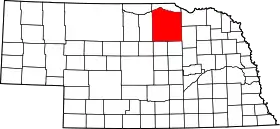 |
| مقاطعة هوكر | 091 | Mullen | 1889 | Unorganized territory | جوزيف هوكر, an الحرب الأهلية الأمريكية general | 93 | 783 | 721 sq mi (1٬867 كم2) | 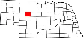 |
| مقاطعة هاورد | 093 | Saint Paul | 1871 | Formed from Hall County | أوليفر هوارد, an الحرب الأهلية الأمريكية general | 49 | 6٬567 | 570 sq mi (1٬476 كم2) | 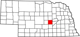 |
| مقاطعة جيفيرسون | 095 | Fairbury | 1856 | Unorganized territory | توماس جفرسون, the third رئيس الولايات المتحدة | 33 | 8٬333 | 573 sq mi (1٬484 كم2) | 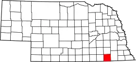 |
| مقاطعة جونسون | 097 | Tecumseh | 1857 | Formed from Nemaha and Otoe Counties | ريتشارد مينتور جونسون, the ninth نائب رئيس الولايات المتحدة | 57 | 4٬488 | 376 sq mi (974 كم2) | 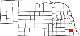 |
| مقاطعة كيارني | 099 | Minden | 1860 | Unorganized territory | Named for Fort Kearny - when the county was created the fort's name was misspelled | 52 | 6٬882 | 516 sq mi (1٬336 كم2) | 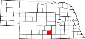 |
| مقاطعة كيث | 101 | Ogallala | 1873 | Unorganized territory | M. C. Keith, who owned one of the largest ranches in western نبراسكا at the time | 68 | 8٬875 | 1٬061 sq mi (2٬748 كم2) | 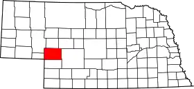 |
| مقاطعة كياباها | 103 | Springview | 1884 | Formed from Brown County and unorganized Indian territory | لاكوتا (قبائل) words Ké-ya Pa-há Wa-kpá, which, translated, mean turtle hill river | 82 | 983 | 773 sq mi (2٬002 كم2) | 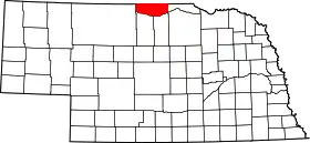 |
| مقاطعة كيمبل | 105 | Kimball | 1888 | Formed from Cheyenne County | Thomas L. Kimball, an official of the Union Pacific Railroad | 71 | 4٬089 | 952 sq mi (2٬466 كم2) | 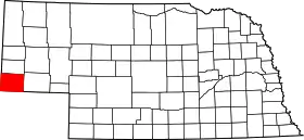 |
| مقاطعة كنوكس | 107 | Center | 1857 | Formed from Pierce County and unorganized territory (Former names-L'Eau Qui Court (1857-1867) and Emmet (1867-1873)) | هنري نوكس, the first وزير حرب الولايات المتحدة | 12 | 9٬374 | 1٬108 sq mi (2٬870 كم2) | 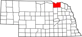 |
| مقاطعة لانكستر | 109 | Lincoln | 1855 | Formed from Cass and Pierce Counties | The cities of لانكستر and لانكستر (إنجلترا). | 2 | 250٬291 | 839 sq mi (2٬173 كم2) | 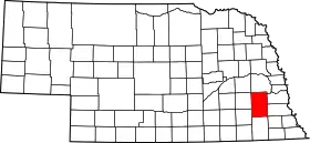 |
| مقاطعة لينكون | 111 | North Platte | 1860 | Unorganized territory | أبراهام لينكون, the sixteenth رئيس الولايات المتحدة | 15 | 34٬632 | 2٬564 sq mi (6٬641 كم2) | 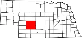 |
| مقاطعة لوغن | 113 | Stapleton | 1885 | Unorganized territory | جون أ لوجان, a general in the الحرب الأهلية الأمريكية | 87 | 774 | 571 sq mi (1٬479 كم2) | 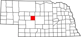 |
| مقاطعة لوب | 115 | Taylor | 1883 | Unorganized territory | Loup River which in turn is named for the French word loup which means wolf | 88 | 712 | 570 sq mi (1٬476 كم2) | 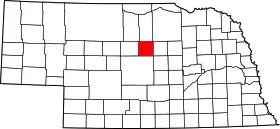 |
| مقاطعة ماديسون | 119 | Madison | 1856 | Formed from Loup County, and McNeale County, and unorganized territory | Either جيمس ماديسون, the fourth رئيس الولايات المتحدة؛ or, more likely, ماديسون (مقاطعة دان), where most of the new county's settlers were from | 7 | 35٬226 | 573 sq mi (1٬484 كم2) | 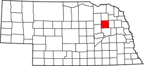 |
| مقاطعة ماكفرسون | 117 | Tryon | 1887 | Unorganized territory | جيمس بي. ماكفيرسون, a general in the الحرب الأهلية الأمريكية | 90 | 533 | 859 sq mi (2٬225 كم2) | 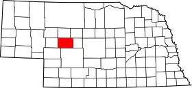 |
| مقاطعة ميريك | 121 | Central City | 1858 | Formed from Polk County and unorganized territory | Elvira Merrick, wife of Henry W. DePuy, a territorial legislator | 46 | 8٬204 | 485 sq mi (1٬256 كم2) | 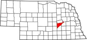 |
| مقاطعة موريل | 123 | Bridgeport | 1908 | Formed from Cheyenne County | Charles Henry Morrill, a president of the Lincoln Land Company | 64 | 5٬440 | 1٬424 sq mi (3٬688 كم2) | 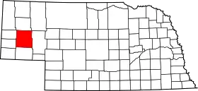 |
| مقاطعة نانس | 125 | Fullerton | 1879 | Formed from a Pawnee Indian reservation | Albinus Nance, the fourth governor of Nebraska | 58 | 4٬038 | 441 sq mi (1٬142 كم2) | 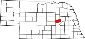 |
| مقاطعة نيهاما | 127 | Auburn | 1854 | One of nine original counties | Nimaha, the Oto name meaning miry water for a stream which crossed the county and emptied into the نهر ميزوري | 44 | 7٬576 | 409 sq mi (1٬059 كم2) | 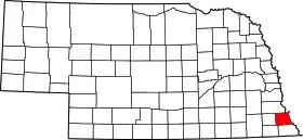 |
| مقاطعة نوكولس | 129 | Nelson | 1860 | Unorganized territory | Lafayette Nuckolls, a member of the first نبراسكا territorial legislature; and his brother, Stephen Nuckolls, a pioneering نبراسكا settler, businessman and banker | 42 | 5٬057 | 575 sq mi (1٬489 كم2) | 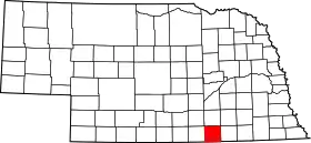 |
| مقاطعة أوتوي | 131 | Nebraska City | 1854 | One of nine original counties | Oto (also Otoe) السكان الأصليون في الولايات المتحدة tribe | 11 | 15٬396 | 616 sq mi (1٬595 كم2) | 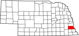 |
| مقاطعة باوني | 133 | Pawnee City | 1855 | Formed from Richardson County | باوني السكان الأصليون في الولايات المتحدة tribe | 54 | 3٬087 | 432 sq mi (1٬119 كم2) | 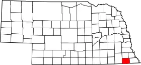 |
| مقاطعة بركينس | 135 | Grant | 1887 | Formed from Keith County | Charles E. Perkins, a president of the Chicago, Burlington and Quincy Railroad | 74 | 3٬200 | 883 sq mi (2٬287 كم2) | 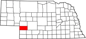 |
| مقاطعة فيلبس | 137 | Holdrege | 1873 | Formed from Kearney County | William Phelps, a riverboat captain on the نهر المسيسيبي who is alleged to have settled in the area | 37 | 9٬747 | 540 sq mi (1٬399 كم2) | 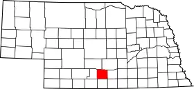 |
| مقاطعة بيرسي | 139 | Pierce | 1856 | Formed from Izard County, McNeale County, and unorganized territory | فرانكلين بيرس, the fourteenth رئيس الولايات المتحدة | 40 | 7٬857 | 574 sq mi (1٬487 كم2) | 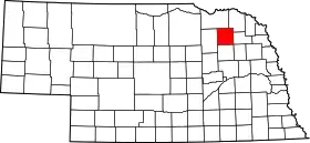 |
| مقاطعة بلاتي | 141 | Columbus | 1856 | Formed from Greene and Loup Counties | Platte River which is in turn named for the French word for flat | 10 | 31٬662 | 678 sq mi (1٬756 كم2) | 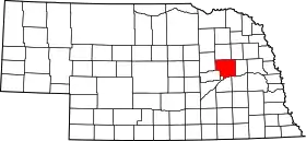 |
| مقاطعة بولك | 143 | Osceola | 1856 | Formed from York County and unorganized territory | جيمس بوك, the eleventh رئيس الولايات المتحدة | 41 | 5٬639 | 439 sq mi (1٬137 كم2) | 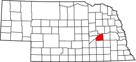 |
| مقاطعة رد ويلو | 145 | McCook | 1873 | Unorganized territory | Red Willow Creek, which runs through the area | 48 | 11٬448 | 717 sq mi (1٬857 كم2) | 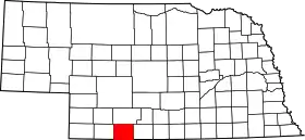 |
| مقاطعة ريتشاردسون | 147 | Falls City | 1854 | One of nine original counties | وليام الكسندر ريتشاردسون, a governor of the Nebraska Territory | 19 | 9٬531 | 554 sq mi (1٬435 كم2) | 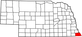 |
| مقاطعة روك | 149 | Bassett | 1885 | Formed from Brown County | Either Rock Creek, which flows in the county; or the rocky condition of the تربة in the area | 81 | 1٬756 | 1٬008 sq mi (2٬611 كم2) | 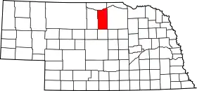 |
| مقاطعة سالين | 151 | Wilber | 1867 | Unorganized territory | Named for a belief held by the early pioneers that great ملح الطعام springs and deposits could be found in the area, a hope found to be false | 22 | 13٬843 | 575 sq mi (1٬489 كم2) | 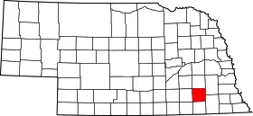 |
| مقاطعة ساربي | 153 | Papillion | 1857 | Formed from Cass and Douglas Counties | Peter A. Sarpy, a commander of a trading post in the future county | 59 | 122٬595 | 241 sq mi (624 كم2) | 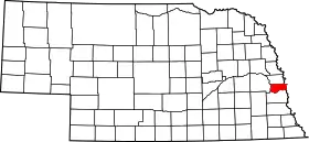 |
| مقاطعة ساوندرس | 155 | Wahoo | 1856 | Formed from Douglas and Lancaster Counties | آلفين سوندرز, a governor of the Nebraska Territory | 6 | 19٬830 | 754 sq mi (1٬953 كم2) | 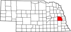 |
| مقاطعة سوكتس بلوف | 157 | Gering | 1888 | Formed from Cheyenne County | Named for a towering bluff located in the Scotts Bluff National Monument؛ the bluffs themselves are named for Hiram Scott, a fur trapper who is alleged to have crawled 75 miles with a broken leg before collapsing and dying at the foot of the formation | 21 | 36٬951 | 739 sq mi (1٬914 كم2) | 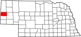 |
| مقاطعة سيوارد | 159 | Seward | 1855 | Formed from Cass and Pierce Counties | ويليام سيوارد, the وزير الخارجية الأمريكي during the 1860s | 16 | 16٬496 | 575 sq mi (1٬489 كم2) | 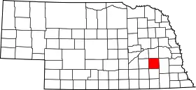 |
| مقاطعة شيردان | 161 | Rushville | 1885 | Formed from Sioux County | فيليب شيريدان, a general in the الحرب الأهلية الأمريكية | 61 | 6٬198 | 2٬441 sq mi (6٬322 كم2) | 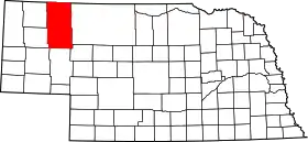 |
| مقاطعة شيرمان | 163 | Loup City | 1871 | Formed from Buffalo County and unorganized territory | ويليام شيرمان, the الحرب الأهلية الأمريكية general | 56 | 3٬318 | 566 sq mi (1٬466 كم2) | 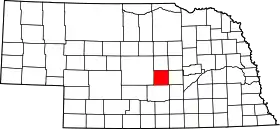 |
| مقاطعة سيوكس | 165 | Harrison | 1877 | Unorganized territory | سايوكس السكان الأصليون في الولايات المتحدة tribe | 80 | 1٬475 | 2٬067 sq mi (5٬354 كم2) | 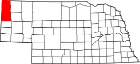 |
| مقاطعة ستانتون | 167 | Stanton | 1855 | Formed from Burt County | إدوين ستانتون, the وزير حرب الولايات المتحدة during most of the الحرب الأهلية الأمريكية | 53 | 6٬455 | 430 sq mi (1٬114 كم2) | 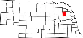 |
| مقاطعة ثاير | 169 | Hebron | 1871 | Formed from Jefferson County | جون ميلتون ثاير, the seventh governor of Nebraska | 32 | 6٬055 | 575 sq mi (1٬489 كم2) | 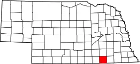 |
| مقاطعة توماس | 171 | Thedford | 1887 | Unorganized territory | جورج هنري توماس, a general in the الحرب الأهلية الأمريكية | 89 | 729 | 713 sq mi (1٬847 كم2) | 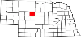 |
| مقاطعة ثورستون | 173 | Pender | 1889 | Formed form Blackbird County and an Omaha Indian reservation | John Mellen Thurston, a U. S. senator from نبراسكا | 55 | 7٬171 | 394 sq mi (1٬020 كم2) | 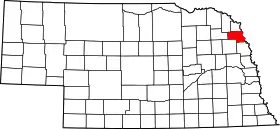 |
| مقاطعة فالي | 175 | Ord | 1871 | Unorganized territory | Named for the many valleys in the area | 47 | 4٬647 | 568 sq mi (1٬471 كم2) | 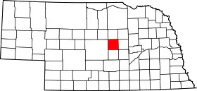 |
| مقاطعة واشنطن | 177 | Blair | 1854 | One of nine original counties | جورج واشنطن, the first رئيس الولايات المتحدة | 29 | 18٬780 | 390 sq mi (1٬010 كم2) | 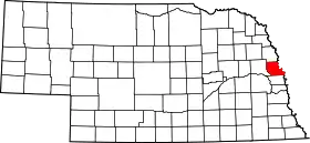 |
| مقاطعة وايني | 179 | Wayne | 1867 | Unorganized territory | أنتوني واين, the حرب الاستقلال الأمريكية general nicknamed "Mad Anthony" by his troops | 27 | 9٬851 | 444 sq mi (1٬150 كم2) | 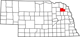 |
| مقاطعة وبستر | 181 | Red Cloud | 1867 | Unorganized territory | دانيال وبستر, the statesman and U.S. Senator from Massachusetts | 45 | 4٬061 | 575 sq mi (1٬489 كم2) | 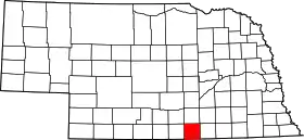 |
| مقاطعة ويلر | 183 | Bartlett | 1877 | Unorganized territory | Daniel H. Wheeler, a secretary of the Nebraska State Board of Agriculture | 84 | 886 | 575 sq mi (1٬489 كم2) | 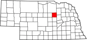 |
| مقاطعة يورك | 185 | York | 1855 | Formed from Cass County, Pierce County, and unorganized territory | Named for either يورك, or مقاطعة يورك (بنسيلفانيا) | 17 | 14٬598 | 576 sq mi (1٬492 كم2) |  |
Former counties of Nebraska:
- Clay (1855-1864) Formed from unorganized territory and dissolved into Gage and Lancaster County.
- Jackson (1855-1856) Formed from unorganized territory and dissolved to Fillmore County and unorganized territory
- Johnson (1855-1856) Formed from unorganized territory and dissolved to unorganized territory
- Blackbird (1855-1888) Formed from Burt County and dissolved to Thurston County
- Loup (1855-1856) Formed from Burt and Un-Organized and then dissolved Madison, Monroe and Platte Counties
- Jones (1856-1866) Formed from unorganized territory and dissolved into Jefferson County.
- Grant, Harrison, Jackson, Lynn, Monroe and Taylor counties listed in 1870 - see map
- West (1860-1862) Formed from unorganized territory and dissolved into Holt County
مراجع
- "EPA County FIPS Code Listing". EPA.gov. مؤرشف من الأصل في 01 أكتوبر 2015. اطلع عليه بتاريخ 04 مايو 2008. الوسيط
|CitationClass=تم تجاهله (مساعدة); تحقق من التاريخ في:|تاريخ أرشيف=(مساعدة) - National Association of Counties. "NACo - Find a county". مؤرشف من الأصل في 13 فبراير 2007. اطلع عليه بتاريخ 04 مايو 2008. الوسيط
|CitationClass=تم تجاهله (مساعدة) - The license plate prefix sequence is derived from the number of vehicles registered in each county in 1922.
- Fitzpatrick, Lilian Linder (1925). "Nebraska Place-Names". University of Nebraska Department of English. Retrieved 2010-09-02. نسخة محفوظة 01 أغسطس 2017 على موقع واي باك مشين.
في كومنز صور وملفات عن: قائمة مقاطعات نبراسكا
 بوابة الولايات المتحدة
This article is issued from Wikipedia. The text is licensed under Creative Commons - Attribution - Sharealike. Additional terms may apply for the media files.