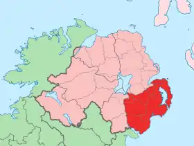
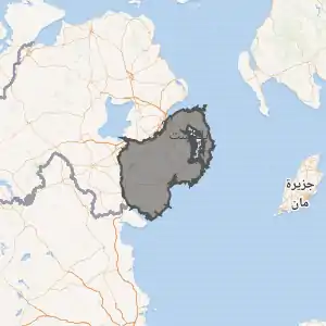
مقاطعة داون
مقاطعة داون هي إحدى مقاطعات أيرلندا الشمالية الستة.[3][4]
| مقاطعة داون | ||
|---|---|---|
| ||
 | ||

| ||
| إحداثيات: 54°22′N 5°56′W [1] | ||
| تقسيم إداري | ||
| البلد | ||
| التقسيم الأعلى | أيرلندا الشمالية (3 مايو 1921–) | |
| خصائص جغرافية | ||
| المساحة | 2448 كيلومتر مربع | |
| معلومات أخرى | ||
| منطقة زمنية | ت ع م±00:00 | |
مراجع
- "صفحة مقاطعة داون في خريطة الشارع المفتوحة". OpenStreetMap. اطلع عليه بتاريخ 4 مارس 2021. الوسيط
|CitationClass=تم تجاهله (مساعدة) - "صفحة مقاطعة داون في ميوزك برينز". MusicBrainz area ID. اطلع عليه بتاريخ 4 مارس 2021. الوسيط
|CitationClass=تم تجاهله (مساعدة) - Taylor, Isaac. Names and Their Histories. Rivingtons, 1898. p.111
- Lewis, Samuel. A Topographical Dictionary of Ireland (1837); "The See of Down". نسخة محفوظة 01 أغسطس 2017 على موقع واي باك مشين.
روابط إضافية
- White Image - County Down Art Gallery
- Iúr FM - Newry Radio Station
- Bangor FM - County Down Radio Station
- County Down website
- Armagh and Down Tourism
- Culture Northern Ireland - Industrial Heritage of County Down
- Down Gaelic Athletic Association/Cummann Lúthchleas Gael Coiste An Dún
- Genealogy indexes for County Down
- Ardglass Fishing port on East Down coast
في كومنز صور وملفات عن: مقاطعة داون
- بوابة المملكة المتحدة
- بوابة أيرلندا
- بوابة أيرلندا الشمالية
This article is issued from Wikipedia. The text is licensed under Creative Commons - Attribution - Sharealike. Additional terms may apply for the media files.

