أرخبيل بسمارك
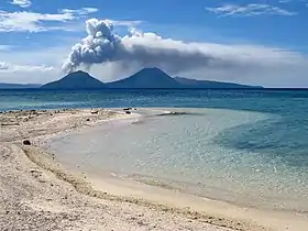
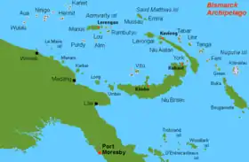
أرخبيل بسمارك (بالإنجليزية: Bismarck Archipelago) أَرْخِبِيل بِسمارك مجموعةُ جزرٍ في جنوب غربي المحيط الهادئ.[1] تمتد الجزر إلى شمال شرقي غينيا الجديدة وهي جزء من دولة بابوا غينيا الجديدة. يتألف أرخبيل بسمارك من أكثر من 200 جزيرة ، مجموع مساحتها مع القسم المتصل باليابسة نحو 48,640كم². أكبر جزيرتين فيه هما جزيرة نيو بريتن بمساحة 36,500كم² ونيو أيرلاند، بمساحة 8,650كم²، وتشمل الجزر الرئيسية الأخرى مانوس وهانوفر الجديدة. وتُكوّن جزيرة مانوس أكبر جزر أدمير، التي هي جزء من الأرخبيل. ومعظم الجزر الأخرى في أرخبيل بسمارك أصغر مساحة. وتتميز جزر نيو بريتن ونيو أيرلاند ومانوس، بسلاسل جبالٍ وعرةٍ وغابات كثيفةٍ. وتتصف جزيرة نيو بريتن بالبركانيّة. والعديدُ من الجزر الصغيرة منبسطةً، وتُكون بعضها جزرًا مرجانيّة (حيودًا بحرية مرجانية حلقية الشكل). يتمتع أرخبيل بسمارك الواقع قرب خط الاستواء بمناخٍ حار رطب، ويقع بمستوى سطح البحر ومعدل درجة الحرارة القصوى فيه ما بين 24° و31° مئوية. يبلغ عدد سكان أرخبيل بسمارك حوالي 430,000 نسمة. يعيش 70% من السكان على جزيرة نيو بريتن، و20% منهم على جزيرة نيو أيرلاند. يشكل الميلانيزيون معظم سكان الأرخبيل، وهم ذوو بشرة سمراء وشعر أسود صوفي. يشملُ السكانُ أيضاً عدة مئاتٍ من الصينيين والأوروبيين. يعيشُ معظم السكّانِ في قرى ريفيةٍ صغيرة قريبة من البحر. تُعتبر رابول ـ في نيو بريتن ـ كبرى التجمعات الحضرية، وفيها حوالي 15,000 نسمة. يتكلم الميلانيزيون العديد من اللغات المحلية. وللاتصال بأعضاء من جماعات لغوية مختلفة يستعملون لغة مفهومة على نحو واسع وهي لغة خليط تدعى الإنجليزية الهجين.
| أرخبيل بسمارك | |
|---|---|
 | |
 | |
| إحداثيات | 3°48′31″S 149°01′36″E |
| المساحة (كم²) | 49700 كيلومتر مربع |
| الحكومة | |
| الدولة | |
| التوقيت | ت ع م+10:00 |
| |
المراجع
- Ward, Steven N.; Day, Simon (September 2003). "Ritter Island Volcano —Lateral Collapse and the Tsunami of 1888". Geophysical Journal International. Blackwell Publishing. 154 (3): 891. Bibcode:2003GeoJI.154..891W. doi:10.1046/j.1365-246X.2003.02016.x.
In the early morning of 1888 March 13, roughly 5 km3 of Ritter Island Volcano fell violently into the sea northeast of New Guinea. This event, the largest lateral collapse of an island volcano to be recorded in historical time, flung devastating tsunami tens of metres high on to adjacent shores. Several hundred kilometres away, observers on New Guinea chronicled 3-min period waves up to 8 m high, that lasted for as long as 3 h. These accounts represent the best available first-hand information on tsunami generated by a major volcano lateral collapse. In this article, we simulate the Ritter Island landslide as constrained by a 1985 sonar survey of its debris field and compare predicted tsunami with historical observations. The best agreement occurs for landslides travelling at 40 m/s, but velocities up to 80 m/s cannot be excluded. The Ritter Island debris dropped little more than 800 m vertically and moved slowly compared with landslides that descend into deeper water. Basal friction block models predict that slides with shorter falls should attain lower peak velocities and that 40+ m/s is perfectly compatible with the geometry and runout extent of the Ritter Island landslide. The consensus between theory and observation for the Ritter Island waves increases our confidence in the existence of mega-tsunami produced by oceanic volcano collapses two to three orders of magnitude larger in scale.
الوسيط|CitationClass=تم تجاهله (مساعدة)
- الموسوعة العربية الإسلامية .
.svg.png.webp) بوابة أوقيانوسيا
بوابة أوقيانوسيا بوابة أستراليا
 بوابة بابوا غينيا الجديدة
 بوابة براكين