مقدونيا (اليونان)
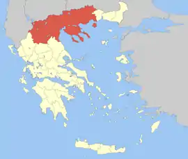
مقدونيا منطقة جغرافية وتاريخية يونانية في جنوب شرق أوروبا، وهو أكبر مناطق اليونان والثانية من حيث عدد السكان. ويشار إليها مع تراقيا بشكل غير رسمي باسم شمال اليونان.
Μακεδονία مقدونيا | |||||
|---|---|---|---|---|---|
— منطقة يونانية — | |||||
| |||||
| |||||
| |||||
| الدولة: | |||||
| العاصمة: | |||||
| الحكومة: | الأمانة العامة لمقدونيا وتراقيا | ||||
| الأمين العام الوزير بالإنابة | جورجيوس تشاتزيكونستانسين سقراطس كسينيدس | ||||
| الأقاليم: | |||||
| تأسست — كمنطقة — 3 أقاليم |
1913[1] 1987[2] | ||||
| السكان: | 2,625,681 نسمة | ||||
| المساحة: | 34,177 كم² | ||||
| الكثافة السكانية: | 77 نسمة/كم² | ||||
| الموقع الرسمي: | www.mathra.gr | ||||
| 1 3 بحكم الأمر الواقع منشور ولكن بصفة غير قانونية.[3] 2 اليونان الدولة الوحيدة التي تجعل رموزها ذات حقوق نشر.[4] 4 جزء من مقدونيا الشرقية وتراقيا. | |||||
تشمل مقدونيا معظم أراضي مملكة مقدونيا القديمة، وهي المملكة التي حكمها الإسكندر الأكبر والده فيليب الثاني. في وقت لاحق، أصبح اسم مقدونيا يطلق على عدة مناطق إدارية مختلفة في الامبراطوريتين الرومانية والبيزنطية، واختلفت حدودها. وتحت حكم العثمانيين، اختفى الاسم تمامًا.
حتى قبل قيام الدولة اليونانية الحديثة عام 1830، كانت مقدونيا تعرف على أنها محافظة يونانية، ولكن دون حدود جغرافية واضحة المعالم.[5][6][7][8] وبحلول منتصف القرن التاسع عشر، أصبحت تعرف بمنطقة مقدونيا، الواقعة جغرافيًا في جنوب البلقان. وفي نهاية عصر الدولة العثمانية، عرفت معظم المنطقة باسم الروملي (باللغة التركية العثمانية:أرض الرومان)، والتي تم تقسيمها وفقًا لمعاهدة بوخارست عام 1913، بعد هزيمة العثمانيين في حروب البلقان عام 1912-1913، بين اليونان وصربيا وبلغاريا، حيث حصلت اليونان على الجزء الأكبر وحصلت ألبانيا على قسم صغير. ظل الجزء اليوناني كمنطقة يونانية حتى عام 1987، حيث أعيد تقسيم المنطقة إلى ثلاثث أقاليم مقدونيا الغربية ومقدونيا الوسطى والجزء الثالث ضمن إقليم مقدونيا الشرقية وتراقيا.[9]
المراجع
- Treaty of Bucharest (1913), 1913
- Π.Δ. 51/87 “Καθορισμός των Περιφερειών της Χώρας για το σχεδιασμό κ.λ.π. της Περιφερειακής Ανάπτυξης” (Determination of the Peripheries of the Country for the planning etc. of the development of the peripheries, Efimeris tis Kyverniseos ΦΕΚ A 26/06.03.1987
- fotw.net نسخة محفوظة 21 فبراير 2014 على موقع واي باك مشين.
- World Intellectual Property Organization: 1st variety, 2nd variety, 3rd variety نسخة محفوظة 14 يناير 2017 على موقع واي باك مشين. [وصلة مكسورة]
- “The whole of Greece is divided into four great pashaliks; Tripolizza, Egripo or Neropont, Yanina, and Salonica. The pashalik of […] Salonica [comprises], the southern divisions of Macedonia. The north of Macedonia is governed by beys;…” Quoted from: Thomas Thornton, The Present State of Turkey, London 1807, Vol. 2, p. 10, Washington.edu نسخة محفوظة 20 أبريل 2016 على موقع واي باك مشين.
- Washington.edu نسخة محفوظة 20 أبريل 2016 على موقع واي باك مشين. [وصلة مكسورة]
- “The most fertile districts of Greece are Macedonia, Thessaly, and the eastern parts of Phocis and Boeotia.” Quoted from: Conder, Josiah: The Modern Traveller, Volume the Fifteenth: Greece. London : J.Duncan, 1830, Vol. 1, p. 12. Archive.org نسخة محفوظة 25 يوليو 2017 على موقع واي باك مشين.
- “There is some difficulty in prescribing the exact boundaries of the country properly called Greece. Formerly it included Macedonia, Peloponnesus, the Ionian Islands, Crete and a part of what is now called Albania. [...] The present divisions of Greece, adopted by the [1829] provisional government, are the following: Eastern Hellas, Western Hellas, Morea, Epirus, Thessaly, Macedonia, Crete, and the Islands. […] What proportion of Macedonia is considered as coming within the boundaries of Greece, we have no means of deciding" Quoted from: John L. Comstock, History of the Greek Revolution compiled from official documents of the Greek government, New York 1829, pages 5 and 6, Google Books نسخة محفوظة 07 ديسمبر 2016 على موقع واي باك مشين.
- Π.Δ. 51/87 “Καθορισμός των Περιφερειών της Χώρας για το σχεδιασμό κ.λ.π. της Περιφερειακής Ανάπτυξης” (Determination of the Peripheries of the Country for the planning etc. of the development of the peripheries, Efimeris tis Kyverniseos ΦΕΚ A 26/06.03.1987
وصلات خارجية
- Macedonian Press Agency
- Museums of Macedonia
- Nikolaos Martis - Macedonia's Hellenism: Empirical documents and sources
- An online review of Macedonian affairs, history and culture
- EMS.name
- University of Macedonia
- University of Western Macedonia
- Macedonia, The Historical Profile of Northern Greece
- Map of Makedonia
- Technological Educational Institution of Serres
- Department of Physical Education Science & Athletics of Serres
- Roman province of Macedonia
- Macedonia, Greece - History And Politics - eBook Greek Language (ISBN 960-6-0337-5)
- Alistrati Cave in Serres
- Lake Kerkini in Serres - Kerkini Wetland (Ramsar & Natura 2000 Protected)
وصلات المواقع الرسمية
- Macedonia and Thrace region site (بالإنجليزية: {{{1}}})
- Ministry for Macedonia–Thrace (باليونانية: {{{1}}})
- Region of Central Macedonia
- Region of Western Macedonia
- Region of Eastern Macedonia and Thrace
- Serres Prefecture
- City of Thessaloniki
- City of Edessa
- City of Serres
- Map of Macedonia
- بوابة اليونان
- بوابة أوروبا
- بوابة الاتحاد الأوروبي
- بوابة اليونان القديم


