قائمة المدن حسب الكثافة السكانية
هذه قائمة المدن حسب الكثافة السكانية. وهي مقياس يستخدم لقياس معدل تواجد السكان في منطقة ما.
قائمة المدن حسب الكثافة السكنية
| الترتيب | المدينة | عدد السكان | المساحة (كم²) | المساحة(ميل²) | الكثافة(/كم²) | الكثافة(/ميل²) | الدولة |
|---|---|---|---|---|---|---|---|
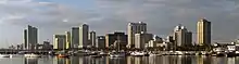
| 1 | مانيلا | 1٬660٬714[1] | 38٫55[2] | 14٫88 | 43٬079 | 111٬576 | |
| 2 | Yonghe | 235٬761[3] | 5٫7138[3] | 2٫2061 | 41٬262 | 106٬867 | |
| 3 | بوكور | 866٬034[4] | 21٫56[5] | 8٫32 | 40٬169 | 104٬037 | |
| 4 | Titagarh | 124٬213[6] | 3٫24[7] | 1٫25 | 38٬337 | 99٬293 | |
| 5 | Baranagar | 250٬768[6] | 7٫12[7] | 2٫75 | 35٬220 | 91٬220 | |
| 6 | Serampore | 197٬857[6] | 5٫88[7] | 2٫27 | 33٬649 | 87٬151 | |
| 7 | باتيروس (الفلبين) | 61٬940 [1] | 2٫1[8] | 0٫81 | 29٬495 | 76٬392 | |
| 8 | دلهي | 12٬565٬901[9] | 431[10][11] | 166٫4 | 29٬155 | 75٬512 | |
| 9 | South Dumdum | 392٬444[6] | 13٫54[7] | 5٫23 | 28٬984 | 75٬069 | |
| 10 | Kamarhati | 314٬507[6] | 10٫96[7] | 4٫23 | 28٬696 | 74٬323 | |
| 11 | كلكتا | 5٬138٬208[9] | 185[10] | 71٫4 | 27٬774 | 71٬935 | |
| 12 | ماندالويونغ | 305٬576[1] | 11٫26[2] | 4٫35 | 27٬138 | 70٬288 | |
| 13 | Luzhou | 197٬466[3] | 7٫4351[3] | 2٫8707 | 26٬559 | 68٬787 | |
| 14 | لوفالوا-بيري | 63٬225[12] | 2٫42[13] | 0٫93 | 26٬126 | 67٬984 | |
| 15 | نيابولي | 30٬279[14] | 1٫17[14] | 0٫45 | 25٬879 | 67٬027 | |
| 16 | كالوكان | 1٬378٬856[1] | 53٫34[2] | 20٫6 | 25٬850 | 66٬952 | |
| 17 | تشيناي | 4٬616٬639[9] | 181٫04[15] | 69٫9 | 25٬501 | 66٬047 | |
| 18 | سوكابومي | 300٬694[4] | 12٫15[5] | 4٫69 | 24٬748 | 64٬099 | |
| 19 | Banciao | 554٬171[3] | 23٫1373[3] | 8٫9334 | 23٬951 | 62٬034 | |
| 20 | Sanchong | 390٬023[3] | 16٫317[3] | 6٫300 | 23٬903 | 61٬908 | |
| 21 | Saint-Josse-ten-Noode | 26٬488[16] | 1٫14[17] | 0٫44 | 23٬235 | 60٬179 | |
| 22 | مالابون | 363٬681[1] | 15٫76[2] | 6٫08 | 23٬076 | 59٬767 | |
| 23 | كاليثيا | 109٬609[18] | 4٫75[18] | 1٫83 | 23٬076 | 59٬767 | |
| 24 | مومباي | 13٬830٬884[9] | 603٫0[11] | 232٫8 | 22٬937 | 59٬406 | |
| 25 | Jaigaon | 38٬689[6] | 1٫69[7] | 0٫65 | 22٬893 | 59٬293 | |
| 26 | نافوتاس | 245٬344[1] | 10٫77[2] | 4٫16 | 22٬780 | 59٬001 | |
| 27 | أمبيلوكيبي | 40٬959[14] | 1٫80[14] | 0٫69 | 22٬755 | 58٬935 | |
| 28 | Banupur | 11٬647[6] | 0٫52[7] | 0٫20 | 22٬398 | 58٬011 | |
| 29 | Bally | 260٬906[6] | 11٫81[7] | 4٫56 | 22٬092 | 57٬218 | |
| 30 | Balurghat | 135٬737[6] | 6٫37[7] | 2٫46 | 21٬309 | 55٬190 | |
| 31 | منزل عطاء | 43٬756[19] | 2٫06[19] | 0٫80 | 21٬241 | 54٬695 | |
| 32 | باساي | 403٬064[1] | 19٫00[2] | 7٫34 | 21٬214 | 54٬944 | |
| 33 | نيا سميرني | 73٬986[18] | 3٫52[18] | 1٫36 | 21٬019 | 54٬439 | |
| 34 | باريس | 2٬203٬817[20] | 105٫4[21][22] | 40٫5 | 20٬909 | 54٬415 | |
| 35 | سان خوان | 124٬187[1] | 5٫94[2] | 2٫29 | 20٬907 | 54٬230 | |
| 36 | Zhonghe | 414٬600[3] | 20٫144[3] | 7٫778 | 20٬582 | 53٬306 | |
| 37 | Xinzhuang | 401٬743[3] | 19٫7383[3] | 7٫6210 | 20٬353 | 52٬715 | |
| 38 | باسيج | 617٬301[1] | 31٫00[2] | 11٫97 | 19٬913 | 51٬575 | |
| 39 | هاورا | 1٬034٬372[9] | 51٫74[7][11] | 19٫98 | 19٬992 | 51٬779 | |
| 40 | دكا | 7٬000٬940[23] | 360٫0[24] | 138٫99 | 19٬447 | 50٬368 | |
| 41 | أحمد آباد | 3٬959٬432[9] | 204 | 78٫8 | 19٬408 | 50٬269 | |
| 42 | أثينا | 745٬514[18] | 38٫96[18] | 15٫04 | 19٬135 | 49٬560 | |
| 43 | Union City | 62٬715[25] | 3٫29 | 1٫27[26] | 19٬066 | 49٬381 | |
| 44 | هوسبيتالت دي يوبريغات | 257٬038[19] | 13٫62[19] | 5٫26 | 18٬872 | 48٬867 | |
| 45 | ماكاتي | 510٬383[1] | 27٫36[2] | 10٫56 | 18٬654 | 48٬315 | |
| 46 | نياتي | 215٬303[6] | 11٫55[7] | 4٫46 | 18٬641 | 48٬280 | |
| 47 | Saint-Gilles | 46٬931[16] | 2٫52[17] | 0٫97 | 18٬623 | 48٬234 | |
| 48 | ماكاو | 542٬200[27] | 29٫2[28] | 11٫3 | 18٬568 | 48٬092 | |
| 49 | الله أباد | 1٬142٬722[9] | 63٫38[11] | 24٫47 | 18٬030 | 46٬697 | |
| 50 | Panihati | 348٬438[6] | 19٫40[7] | 7٫49 | 17٬961 | 46٬519 |
مراجع
- Population of cities of the Philippines(2007 census)Census Bureau of the Philippines. Retrieved 11 June 2009 [وصلة مكسورة] نسخة محفوظة 16 يوليو 2012 على موقع واي باك مشين.
- Cities of the Philippines land area. The Metropolitan Mania Development Authority. Retrieved 31 July 2009 نسخة محفوظة 04 أبريل 2010 على موقع واي باك مشين.
- "Table 1. The Profile of Land 、Population and Budget of All Districts in Taipei county". Department of Budget, Accounting, and Statistics of Taipei County. مؤرشف من الأصل في 31 يوليو 2009. اطلع عليه بتاريخ 24 سبتمبر 2010. الوسيط
|CitationClass=تم تجاهله (مساعدة) - "Pendudukan Menurut Kabupaten/Kota dan Jenis Kelamin" (باللغة الإندونيسية). Provinsi Jawa Barat. مؤرشف من الأصل في 04 أكتوبر 2012. اطلع عليه بتاريخ 24 سبتمبر 2010. الوسيط
|CitationClass=تم تجاهله (مساعدة); تحقق من التاريخ في:|تاريخ أرشيف=(مساعدة) - Cities of Indonesia Statistics Portal Nasional Republik Indonesia (Indonesian). Retrieved 12 June 2009. نسخة محفوظة 22 يناير 2018 على موقع واي باك مشين.
- Census of India; Population Finder Population at the 2001-03-01 Census, final results. Retrieved on 2009-08-22. نسخة محفوظة 02 يوليو 2018 على موقع واي باك مشين.
- Directorate of Census Operations, West Bengal; Population, Decadal Growth Rate, Density and General Sex Ratio by Residence and Sex, West Bengal/ District/ Sub District, 1991 and 2001 Retrieved on 2009-08-22. نسخة محفوظة 22 ديسمبر 2017 على موقع واي باك مشين.
- Pateros Land Area. Municipality of Pateros. Retrieved 18 July 2009. نسخة محفوظة 06 مايو 2013 على موقع واي باك مشين.
- "World: largest cities and towns and statistics of their population". World Gazetteer. مؤرشف من الأصل في 08 مايو 2013. اطلع عليه بتاريخ 07 فبراير 2010. الوسيط
|CitationClass=تم تجاهله (مساعدة); تحقق من التاريخ في:|تاريخ أرشيف=(مساعدة) - United Nations Cities Statistics (pdf-file). The United Nations Retrieved 5 July 2009. نسخة محفوظة 01 فبراير 2017 على موقع واي باك مشين.
- "CHAPTER IV Area and Density – Metropolitan Cities" (PDF). Ministry of Urban Development. Government of India. مؤرشف من الأصل (PDF) في 15 أكتوبر 2012. اطلع عليه بتاريخ 26 أكتوبر 2009. الوسيط
|CitationClass=تم تجاهله (مساعدة) - Levallois-Perret. Institut national de la statistique et des études économiques (French). Retrieved 19 February 2010 "نسخة مؤرشفة". Archived from the original on 19 أكتوبر 2012. اطلع عليه بتاريخ 1 أكتوبر 2010. الوسيط
|CitationClass=تم تجاهله (مساعدة)صيانة CS1: BOT: original-url status unknown (link) - Levallois-Perret land area Wikipedia/FR. Retrieved 19 February 2010
- GeoHive; Greece - Kentrikis Makedonias, Administrative unitsPopulation and area at the 2001-03-18 Census. Retrieved on 2009-08-21.نسخة محفوظة 03 مارس 2016 على موقع واي باك مشين.
- "Development Plan for Chennai Metropolitan Area" (PDF). Govt. of India. 2006. صفحة 1. مؤرشف من الأصل (PDF) في 26 فبراير 2008. اطلع عليه بتاريخ 12 سبتمبر 2007. الوسيط
|CitationClass=تم تجاهله (مساعدة) - Direction Générale Institutions et Population, Belgique; Chiffre global de la population par commune, Situation au 1/07/2009 (pdf-file)Population as of 2009-07-01. Retrieved on 2009-08-21. [وصلة مكسورة] نسخة محفوظة 05 ديسمبر 2013 على موقع واي باك مشين.
- GeoHive; Belgium - Brussels Hoofdstedelijk Gewest, Administrative unitsRetrieved on 2009-08-21.نسخة محفوظة 01 يونيو 2016 على موقع واي باك مشين.
- GeoHive; Greece - Attikis, Administrative unitsPopulation and area at the 2001-03-18 Census. Retrieved on 2009-08-21.نسخة محفوظة 03 مارس 2016 على موقع واي باك مشين.
- Población de España – datos y mapas; Todos los Municipios de España (xls, zipped file)Population and area 2009-01-01. Retrieved on 2010-04-21.نسخة محفوظة 09 أغسطس 2011 على موقع واي باك مشين.
- Paris Population. Institut national de la statistique et des études économiques (French). Retrieved 31 July 2009 نسخة محفوظة 13 سبتمبر 2016 على موقع واي باك مشين.
- Paris land area Demographia. Retrieved 11 June 2009 نسخة محفوظة 23 نوفمبر 2017 على موقع واي باك مشين.
- Includes both the areas غابة بولونيا and غابة فانسن, giving the city a total 105.4km².
- Bangladesh Bureau of Statistics, Statistical Pocket Book, 2008 (pdf-file)2008 Population Estimate. Retrieved on 14 August 2009. [وصلة مكسورة] نسخة محفوظة 15 فبراير 2010 على موقع واي باك مشين.
- "Dhaka Area". Dhaka City Corporation. مؤرشف من الأصل في 23 سبتمبر 2015. اطلع عليه بتاريخ 06 فبراير 2010. الوسيط
|CitationClass=تم تجاهله (مساعدة) - Union City Population U.S. Census Bureau. Retrieved 16 June 2009 نسخة محفوظة 10 أبريل 2010 على موقع واي باك مشين.
- "New Jersey -- Place and County Subdivision". United States Census Bureau. مؤرشف من الأصل في 18 أكتوبر 2008. اطلع عليه بتاريخ 27 مارس 2010. الوسيط
|CitationClass=تم تجاهله (مساعدة) - Statistics and Census Service, Macau SAR Government; Population Estimate of Macao Population as of Qtr. 2, 2009. Retrieved on 2009-03-06. نسخة محفوظة 22 نوفمبر 2017 على موقع واي باك مشين.
- Statistics and Census Service, Macau SAR Government; Total land area of Macao (2007) Retrieved on 2009-08-22. نسخة محفوظة 22 نوفمبر 2017 على موقع واي باك مشين.
وصلات خارجية
 بوابة جغرافيا
 بوابة تجمعات سكانية
This article is issued from Wikipedia. The text is licensed under Creative Commons - Attribution - Sharealike. Additional terms may apply for the media files.