رادار الفتحة التركيبية
رادار الفتحة التركيبية (بالإنجليزية: Synthetic aperture radar) اختصارًا (SAR) هو أحد أشكال الرادار يُستخدم لإنشاء صور ثنائية أو ثلاثية الأبعاد للأشياء، مثل المناظر الطبيعية.[1][2][3]
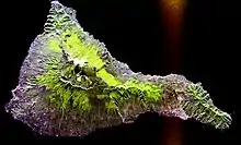
صورة رادارية لجزيرة تنريفي.
مراجع
- "معلومات عن رادار الفتحة التركيبية على موقع britannica.com". britannica.com. مؤرشف من الأصل في 16 مايو 2019. الوسيط
|CitationClass=تم تجاهله (مساعدة) - "معلومات عن رادار الفتحة التركيبية على موقع jstor.org". jstor.org. مؤرشف من الأصل في 10 يناير 2020. الوسيط
|CitationClass=تم تجاهله (مساعدة) - "معلومات عن رادار الفتحة التركيبية على موقع thes.bncf.firenze.sbn.it". thes.bncf.firenze.sbn.it. مؤرشف من الأصل في 10 يناير 2020. الوسيط
|CitationClass=تم تجاهله (مساعدة)
وصلات خارجية
في كومنز صور وملفات عن: رادار الفتحة التركيبية
- InSAR measurements from the Space Shuttle
- Images from the Space Shuttle SAR instrument
- The Alaska Satellite Facility has numerous technical documents, including an introductory text on SAR theory and scientific applications
- NASA radar reveals hidden remains at ancient Angkor – مختبر الدفع النفاث
 بوابة الفيزياء
 بوابة طيران
 بوابة رحلات فضائية
This article is issued from Wikipedia. The text is licensed under Creative Commons - Attribution - Sharealike. Additional terms may apply for the media files.