بوكوبا
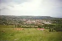
بوكوبا هي مدينة ى صغيرة أو قرية كبيرة في تنزانيا, تقع في الشمال الغربي من البلاد، علي بحيرة فيكتوريا, أحد البحيرات العظمى الأفريقية, وهي أحد أهم منابع لنهر النيل.[1] |population_note = Source: National Census Statistical Book – 2003 |population_total = |population_density_km2 = |population_density_sq_mi = |population_metro = |population_density_metro_km2 = |population_density_metro_sq_mi = |population_urban = 86022 |population_density_urban_km2 = |population_density_urban_sq_mi = |population_blank1_title = Rural |population_blank1 = 395,130 |population_blank2_title = |population_blank2 = |population_density_blank1_km2 = |population_density_blank1_sq_mi = |coordinates = 1°20′S 31°49′E |timezone =توقيت شرق أفريقيا |utc_offset = +3 |timezone_DST = |utc_offset_DST = |elevation_footnotes = |elevation_m = |elevation_ft = |postal_code_type = |postal_code = |area_code = |blank_name = تصنيف كوبن للمناخ |blank_info = Am |blank1_name = |blank1_info = |website = |footnotes = }}</ref>[2] }}</ref> بوكوبا هي عاصمة منطقة كاجيرا. وهي أحد المقاطعات الحدودية لتنزانيا، إذ انها تحدها من الشمال باوغاندا, ومن الغرب برواندا, ومن ثم بوروندي. يقدر تعداد السكان في بوكوبا ب100,000 نسمة، ويخدم المدينة مطار بوكوبا, وتخدمها أيضاً عبارة لمدينة موانزا الواقعة جنوب البحيرة. وتتصل المدينة بمقاطعة راكاي الأوغاندية القريبة لها عن الطريق البري.
المناخ
يظهر الجدول التالي التغييرات المناخية على مدار السنة لبوكوبا:
| البيانات المناخية لـبوكوبا | |||||||||||||
|---|---|---|---|---|---|---|---|---|---|---|---|---|---|
| الشهر | يناير | فبراير | مارس | أبريل | مايو | يونيو | يوليو | أغسطس | سبتمبر | أكتوبر | نوفمبر | ديسمبر | المعدل السنوي |
| الدرجة القصوى °م (°ف) | 30.6 (87.1) |
31.0 (87.8) |
31.4 (88.5) |
31.1 (88.0) |
30.1 (86.2) |
31.1 (88.0) |
30.6 (87.1) |
28.9 (84.0) |
30.0 (86.0) |
29.6 (85.3) |
30.2 (86.4) |
30.3 (86.5) |
31.4 (88.5) |
| متوسط درجة الحرارة الكبرى °م (°ف) | 26.5 (79.7) |
26.6 (79.9) |
26.2 (79.2) |
25.8 (78.4) |
25.6 (78.1) |
25.7 (78.3) |
25.4 (77.7) |
25.5 (77.9) |
25.9 (78.6) |
26.5 (79.7) |
26.2 (79.2) |
26.3 (79.3) |
26.0 (78.8) |
| المتوسط اليومي °م (°ف) | 21.3 (70.3) |
21.4 (70.5) |
21.3 (70.3) |
21.3 (70.3) |
21.2 (70.2) |
20.8 (69.4) |
20.3 (68.5) |
20.4 (68.7) |
20.8 (69.4) |
21.3 (70.3) |
20.9 (69.6) |
20.6 (69.1) |
20.9 (69.6) |
| متوسط درجة الحرارة الصغرى °م (°ف) | 16.1 (61.0) |
16.2 (61.2) |
16.3 (61.3) |
16.8 (62.2) |
16.7 (62.1) |
15.9 (60.6) |
15.2 (59.4) |
15.5 (59.9) |
15.7 (60.3) |
16.2 (61.2) |
15.5 (59.9) |
15.0 (59.0) |
15.9 (60.6) |
| أدنى درجة حرارة °م (°ف) | 11.1 (52.0) |
11.7 (53.1) |
10.6 (51.1) |
10.6 (51.1) |
10.0 (50.0) |
12.2 (54.0) |
10.6 (51.1) |
10.0 (50.0) |
10.9 (51.6) |
10.6 (51.1) |
11.1 (52.0) |
12.8 (55.0) |
10.0 (50.0) |
| الهطول مم (إنش) | 154 (6.1) |
173 (6.8) |
253 (10.0) |
367 (14.4) |
304 (12.0) |
84 (3.3) |
51 (2.0) |
71 (2.8) |
98 (3.9) |
170 (6.7) |
209 (8.2) |
208 (8.2) |
2٬144 (84.4) |
| متوسط أيام هطول الأمطار (≥ 1.0 mm) | 13 | 13 | 18 | 20 | 17 | 6 | 5 | 8 | 10 | 15 | 18 | 16 | 158 |
| متوسط الرطوبة النسبية (%) | 79 | 79 | 79 | 80 | 80 | 77 | 75 | 78 | 78 | 77 | 79 | 78 | 78 |
| المصدر: الأرصاد الجوية الألمانية[3] | |||||||||||||
أعلام
مراجع
- {{Infobox settlement
|official_name = Bukoba
|other_name =
|native_name =
|nickname =
|settlement_type = town
|motto =
|image_skyline =Bukoba View.JPG
|imagesize = 300px
|image_caption =
|image_flag =
|flag_size =
|image_seal =
|seal_size =
|image_shield =
|shield_size =
|image_blank_emblem =
|blank_emblem_type =
|blank_emblem_size =
|image_map =
|mapsize =
|map_caption =
|image_map1 =
|mapsize1 =
|map_caption1 =
|image_dot_map =
|dot_mapsize =
|dot_map_caption =
|dot_x = |dot_y =
|pushpin_map = Tanzania
|pushpin_mapsize =300
|pushpin_label_position =bottom
|pushpin_map_caption =Location in Tanzania
|subdivision_type = Country
|subdivision_name =
 تنزانيا
|subdivision_type1 = أقاليم تنزانيا
|subdivision_name1 = Kagera Region
|subdivision_type2 = District [الإنجليزية]
|subdivision_name2 = Bukoba Urban District
|subdivision_type3 =
|subdivision_name3 =
|subdivision_type4 =
|subdivision_name4 =
|government_footnotes =
|government_type =
|leader_title =
|leader_name =
|leader_title1 =
|leader_name1 =
|leader_title2 =
|leader_name2 =
|leader_title3 =
|leader_name3 =
|leader_title4 =
|leader_name4 =
|established_title =
|established_date =
|established_title2 =
|established_date2 =
|established_title3 =
|established_date3 =
|area_magnitude =
|area_footnotes =
|area_total_km2 =
|area_land_km2 =
|area_water_km2 =
|area_total_sq_mi =
|area_land_sq_mi =
|area_water_sq_mi =
|area_water_percent =
|area_urban_km2 =
|area_urban_sq_mi =
|area_metro_km2 =
|area_metro_sq_mi =
|area_blank1_title =
|area_blank1_km2 =
|area_blank1_sq_mi =
|population_as_of = 2011
|population_footnotes = <ref name=ncsb2003>"Population". National Census Statistical Book – 2003. kagera.org. مؤرشف من الأصل في 22 مايو 2017. الوسيط
تنزانيا
|subdivision_type1 = أقاليم تنزانيا
|subdivision_name1 = Kagera Region
|subdivision_type2 = District [الإنجليزية]
|subdivision_name2 = Bukoba Urban District
|subdivision_type3 =
|subdivision_name3 =
|subdivision_type4 =
|subdivision_name4 =
|government_footnotes =
|government_type =
|leader_title =
|leader_name =
|leader_title1 =
|leader_name1 =
|leader_title2 =
|leader_name2 =
|leader_title3 =
|leader_name3 =
|leader_title4 =
|leader_name4 =
|established_title =
|established_date =
|established_title2 =
|established_date2 =
|established_title3 =
|established_date3 =
|area_magnitude =
|area_footnotes =
|area_total_km2 =
|area_land_km2 =
|area_water_km2 =
|area_total_sq_mi =
|area_land_sq_mi =
|area_water_sq_mi =
|area_water_percent =
|area_urban_km2 =
|area_urban_sq_mi =
|area_metro_km2 =
|area_metro_sq_mi =
|area_blank1_title =
|area_blank1_km2 =
|area_blank1_sq_mi =
|population_as_of = 2011
|population_footnotes = <ref name=ncsb2003>"Population". National Census Statistical Book – 2003. kagera.org. مؤرشف من الأصل في 22 مايو 2017. الوسيط |CitationClass=تم تجاهله (مساعدة) - {{بيانات منطقة مناخية
|location = Bukoba
|single line = Yes
|metric first = Yes
|Jan record high C = 30.6
|Feb record high C = 31.0
|Mar record high C = 31.4
|Apr record high C = 31.1
|May record high C = 30.1
|Jun record high C = 31.1
|Jul record high C = 30.6
|Aug record high C = 28.9
|Sep record high C = 30.0
|Oct record high C = 29.6
|Nov record high C = 30.2
|Dec record high C = 30.3
|year record high C = 31.4
|Jan high C = 26.5
|Feb high C = 26.6
|Mar high C = 26.2
|Apr high C = 25.8
|May high C = 25.6
|Jun high C = 25.7
|Jul high C = 25.4
|Aug high C = 25.5
|Sep high C = 25.9
|Oct high C = 26.5
|Nov high C = 26.2
|Dec high C = 26.3
|year high C = 26.0
|Jan mean C = 21.3
|Feb mean C = 21.4
|Mar mean C = 21.3
|Apr mean C = 21.3
|May mean C = 21.2
|Jun mean C = 20.8
|Jul mean C = 20.3
|Aug mean C = 20.4
|Sep mean C = 20.8
|Oct mean C = 21.3
|Nov mean C = 20.9
|Dec mean C = 20.6
|year mean C = 20.9
|Jan low C = 16.1
|Feb low C = 16.2
|Mar low C = 16.3
|Apr low C = 16.8
|May low C = 16.7
|Jun low C = 15.9
|Jul low C = 15.2
|Aug low C = 15.5
|Sep low C = 15.7
|Oct low C = 16.2
|Nov low C = 15.5
|Dec low C = 15.0
|year low C = 15.9
|Jan record low C = 11.1
|Feb record low C = 11.7
|Mar record low C = 10.6
|Apr record low C = 10.6
|May record low C = 10.0
|Jun record low C = 12.2
|Jul record low C = 10.6
|Aug record low C = 10.0
|Sep record low C = 10.9
|Oct record low C = 10.6
|Nov record low C = 11.1
|Dec record low C = 12.8
|year record low C = 10.0
|precipitation colour = green
|Jan precipitation mm = 154
|Feb precipitation mm = 173
|Mar precipitation mm = 253
|Apr precipitation mm = 367
|May precipitation mm = 304
|Jun precipitation mm = 84
|Jul precipitation mm = 51
|Aug precipitation mm = 71
|Sep precipitation mm = 98
|Oct precipitation mm = 170
|Nov precipitation mm = 209
|Dec precipitation mm = 208
|year precipitation mm = 2144
|unit precipitation days = 1.0 mm
|Jan precipitation days = 13
|Feb precipitation days = 13
|Mar precipitation days = 18
|Apr precipitation days = 20
|May precipitation days = 17
|Jun precipitation days = 6
|Jul precipitation days = 5
|Aug precipitation days = 8
|Sep precipitation days = 10
|Oct precipitation days = 15
|Nov precipitation days = 18
|Dec precipitation days = 16
|year precipitation days = 158
|Jan humidity = 79
|Feb humidity = 79
|Mar humidity = 79
|Apr humidity = 80
|May humidity = 80
|Jun humidity = 77
|Jul humidity = 75
|Aug humidity = 78
|Sep humidity = 78
|Oct humidity = 77
|Nov humidity = 79
|Dec humidity = 78
|year humidity = 78
|source 1 = الأرصاد الجوية الألمانية<ref name = DWD>
"Klimatafel von Bukoba / Tansania" (PDF). Baseline climate means (1961-1990) from stations all over the world (باللغة الألمانية). Deutscher Wetterdienst. مؤرشف من الأصل (PDF) في 19 أبريل 2019. اطلع عليه بتاريخ 22 مايو 2016. الوسيط
|CitationClass=تم تجاهله (مساعدة) - "Klimatafel von Bukoba / Tansania" (PDF). Baseline climate means (1961-1990) from stations all over the world (باللغة الألمانية). Deutscher Wetterdienst. مؤرشف (PDF) من الأصل في 19 أبريل 2019. اطلع عليه بتاريخ 22 مايو 2016. الوسيط
|CitationClass=تم تجاهله (مساعدة)
 بوابة تجمعات سكانية
 بوابة أوغندا
 بوابة جغرافيا
 بوابة تنزانيا