خريطة غودونوف
خريطة غودونوف هي خريطة اثنوغرافية لسيبيريا بتكليف من ألكسيس روسيا في 15 تشرين الثاني/نوفمبر 1667.[1] النسخة الأصلية من الخريطة لم تعد موجودة، ولكن تم عمل نسختين من الخريطة. أحدها من اعداد بريتس يوهانسون كلاس والأخرى من كرونمان فريتز.[2] [3] سميت باسم بيتر إيفانوفيتش غودونوف حاكم توبولسك.[1][4][5]
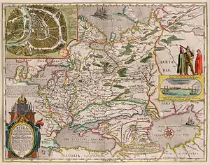
خريطة غودونوف والتي نشرت في امستردام
مراجع
- Imago mundi. International Society for the History of Cartography. مؤرشف من الأصل في 25 يناير 2020.
On the 15th of November 1667 the Tsar Alexey Mikhailovitch gave order to the Governor of Tobolsk, Petr Godunov, and his comrades to make a map with the ...
الوسيط|CitationClass=تم تجاهله (مساعدة) - "Isis, Volume 4". History of Science Society, Académie internationale d'histoire des sciences. 1922. مؤرشف من الأصل في 25 يناير 2020.
A copy made by the Swedish envoy to Russia, Fritz Cronman (or Kroneman) in 1669, is reproduced. ...
الوسيط|CitationClass=تم تجاهله (مساعدة); Cite journal requires|journal=(مساعدة) - Laura Hostetler. Qing colonial enterprise: ethnography and cartography in early modern China. مؤرشف من الأصل في 25 يناير 2020.
... The other was made by Fritz Cronman.
الوسيط|CitationClass=تم تجاهله (مساعدة) - The equivalent of a حاكم الدولة
- Nicholas B. Breyfogle, Abby M. Schrader, and Willard Sunderland (2007). Peopling the Russian periphery: borderland colonization in Eurasian history. ISBN 0415418801. مؤرشف من الأصل في 25 يناير 2020.
The first surviving map of all of Siberia, the so-called Godunov map of 1667 (named after a Siberian governor, not the tsar), divides the territory with ...
الوسيط|CitationClass=تم تجاهله (مساعدة)صيانة CS1: أسماء متعددة: قائمة المؤلفون (link)
 بوابة جغرافيا
This article is issued from Wikipedia. The text is licensed under Creative Commons - Attribution - Sharealike. Additional terms may apply for the media files.