المحافظة الشرقية (زامبيا)
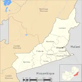
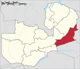
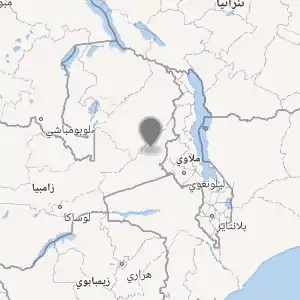
المحافظة الشرقية هي إحدى محافظات زامبيا العشرة.[3][4][5] تقع المحافظة بين نهر لوانغوا والحدود مع ملاوي إلى الشرق وموزمبيق إلى الجنوب، من إيسوكا في الشمال الشرقي إلى لوانغوا في الجنوب.[6] عاصمتها شيباتا وتنقسم إلى 8 مناطق.
| المحافظة الشرقية (زامبيا) | |
|---|---|
 | |
 | |
| |
| إحداثيات: 13°00′S 32°15′E | |
| تقسيم إداري | |
| البلد | |
| التقسيم الأعلى | زامبيا |
| العاصمة | تشيباتا |
| خصائص جغرافية | |
| المساحة | 51476.0 كيلومتر مربع |
| ارتفاع | 818 متر |
| رمز جيونيمز | 917388 |
| أيزو 3166 | ZM-03[2] |
المناخ
يظهر الجدول التالي التغييرات المناخية على مدار السنة لالمحافظة الشرقية:
{{بيانات منطقة مناخية
| location = المحافظة الشرقية
|width=auto
| metric first = Yes
| single line = Yes
| Jan record high C = 27.8
| Feb record high C = 28
| Mar record high C = 28.3
| Apr record high C = 28.3
| May record high C = 27.6
| Jun record high C = 26.1
| Jul record high C = 26.1
| Aug record high C = 27.4
| Sep record high C = 30.7
| Oct record high C = 31.4
| Nov record high C = 30.9
| Dec record high C = 28.8
| year record high C = 31.4
| Jan low C = 18.2
| Feb low C = 17.9
| Mar low C = 17.4
| Apr low C = 16
| May low C = 13.6
| Jun low C = 11
| Jul low C = 10.6
| Aug low C = 12.7
| Sep low C = 17
| Oct low C = 18.7
| Nov low C = 19.1
| Dec low C = 18.7
| year low C = 10.6
| precipitation colour = green
| Jan precipitation mm = 21
| Feb precipitation mm = 16
| Mar precipitation mm = 14
| Apr precipitation mm = 6
| May precipitation mm = 1
| Jun precipitation mm = 0
| Jul precipitation mm = 0
| Aug precipitation mm = 0
| Sep precipitation mm = 0
| Oct precipitation mm = 2
| Nov precipitation mm = 8
| Dec precipitation mm = 18
| year precipitation mm = 86
| source 1 =<ref>"Weather statistics for Eastern (Zambia)". المحافظة الشرقية: Norwegian Meteorological Institute and Norwegian Broadcasting Corporation. October 2016. اطلع عليه بتاريخ 20 أكتوبر 2016. الوسيط |CitationClass= تم تجاهله (مساعدة); تحقق من التاريخ في: |year= / |date= mismatch (مساعدة)
مراجع
- "صفحة المحافظة الشرقية (زامبيا) في GeoNames ID". GeoNames ID. اطلع عليه بتاريخ 4 مارس 2021. الوسيط
|CitationClass=تم تجاهله (مساعدة) - الناشر: مؤسسة ميتا برينز
- "Labour force survey". Central Statistical Office of Zambia. 2008. مؤرشف من الأصل في 07 أغسطس 2017. اطلع عليه بتاريخ 17 أكتوبر 2016. الوسيط
|CitationClass=تم تجاهله (مساعدة); تحقق من التاريخ في:|تاريخ أرشيف=(مساعدة) - "Atlas Home". Zambia data portal, Central statistical Office of Zambia. 2011. مؤرشف من الأصل في 12 ديسمبر 2017. اطلع عليه بتاريخ 16 أكتوبر 2016. الوسيط
|CitationClass=تم تجاهله (مساعدة) - "Weather statistics for Eastern (Zambia)". Norway: Norwegian Meteorological Institute and Norwegian Broadcasting Corporation. 2007. مؤرشف من الأصل في 21 أكتوبر 2016. اطلع عليه بتاريخ 20 أكتوبر 2016. الوسيط
|CitationClass=تم تجاهله (مساعدة) - Simon, David J.; Pletcher, James R.; Siegel, Brian V., المحررون (2008). "Eastern Province". Historical Dictionary of Zambia. 106 (الطبعة 3rd). Metuchen, New Jersey: Scarecrow Press. صفحة 104. ISBN 978-0-8108-5305-8. الوسيط
|CitationClass=تم تجاهله (مساعدة)
.svg.png.webp) بوابة أفريقيا
بوابة أفريقيا بوابة زامبيا